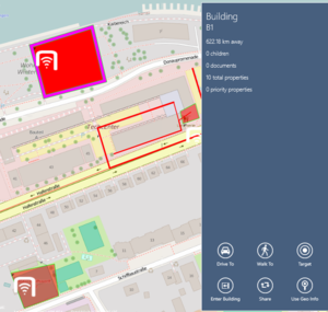
Geography objects are objects carrying multiple geo coordinates as well as other information for visualizing different shapes on the map. The existing geography types are lines and polygons.
UI representation
Geography objects are visualized based on their types and their geography related property values, e.g. line color, fill color, etc. They are scaled as the zoom level of the map changes. Also they move and rotate with the map when panning and rotating the map. Like regular map POIs, they can be selected and viewed in details as well. The outline of the selected one is highlighted (special color and extra thickness).
Details flyout panel
Once a geography object is selected, its details are shown in a flyout panel just as for regular POIs. In any case, the following is shown.
- Name;
- Description;
- Number of children, properties, documents;
- Priority properties;
- A "Target" button to browse to the object;
- A "Share" button to make a snapshot of the content with the map background.
For geo objects
If a geography object happens to be a geo object carrying a valid geo coordinate, the following is shown in addition.
- The distance to the geo coordinate;
- A "Drive To" and a "Walk To" button to navigate to the geo coordinate;
- A "Use Geo Info" button to take the geo coordinate as the user location.
For groups and buildings
If a geography object happens to be a group or a building, the following is shown in addition to the ones for geo objects. (Because groups/buildings are by definition also geo objects.)
- An "Open POI Group" button to open the group;
- Or an "Enter Building" button to enter the building.
Group and layer filtering
When a geography object happens to be a group, a group item or a layer item, its visibility is determined by the existing group and layer filtering mechanism.
