Difference between revisions of "Building Levels"
(→UI) |
m (→Appearance) |
||
| (7 intermediate revisions by one other user not shown) | |||
| Line 2: | Line 2: | ||
The feature is available both on the {{UBIK}} WinX and Android clients. | The feature is available both on the {{UBIK}} WinX and Android clients. | ||
| − | == | + | == Appearance == |
| − | The feature is available for the {{UBIK}} WinX and Android clients {{Version/AndroidSince|2.5.0}} | + | The feature is available for the {{UBIK}} WinX and Android clients and appears in map and AR views. {{Version/AndroidSince|2.5.0}} |
| − | After selecting a point of interest (by clicking at it), there is the possibility to enter the building using the {{key press|Enter Building}} button. | + | After selecting a point of interest that is also a building (by clicking at it), there is the possibility to enter the building using the {{key press|Enter Building}} button. |
| − | Once a building is | + | Once a building is entered, a HuD (Head-up-Display, user interface a view is overlaid with) for selecting the desired building level is available. |
For the Android client, the building can be exited using the {{key press|<}} button in the Action Bar. | For the Android client, the building can be exited using the {{key press|<}} button in the Action Bar. | ||
| − | For the | + | For the Windows client, the building can be exited using the back arrow button {{key press|←}} in the context bar on the left of the view. |
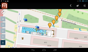
[[File:UI_Android_Map_Building_Levels.png|thumb|alt=Building Levels UI (Android)|Building Levels UI (Android)]] | [[File:UI_Android_Map_Building_Levels.png|thumb|alt=Building Levels UI (Android)|Building Levels UI (Android)]] | ||
| Line 16: | Line 16: | ||
In the map view, there can also be map overlays for a building level. | In the map view, there can also be map overlays for a building level. | ||
| + | [[Category:Client|Building Levels]] | ||
== Configuration == | == Configuration == | ||
| Line 25: | Line 26: | ||
Building levels require an altitude the level is at (not the height of the room), a level index (ground floor = 0) and their parent POI group (the building). | Building levels require an altitude the level is at (not the height of the room), a level index (ground floor = 0) and their parent POI group (the building). | ||
| − | A building level can also contain map overlays, which will be displayed only when the respective level is opened. | + | A building level can also contain map overlays ([[SYSCLS_MAPOVERLAY|Map Overlay Classification]]) as POI group items, which will be displayed only when the respective level is opened. |
| + | |||
| + | [[Category:Client|Building Levels]] | ||
Latest revision as of 10:09, 2 May 2016
As an extension to the POI Groups, buildings and building levels can be configured in order to provide indoor map and AR features. The feature is available both on the UBIK® WinX and Android clients.
Appearance
The feature is available for the UBIK® WinX and Android clients and appears in map and AR views.
After selecting a point of interest that is also a building (by clicking at it), there is the possibility to enter the building using the Enter Building button. Once a building is entered, a HuD (Head-up-Display, user interface a view is overlaid with) for selecting the desired building level is available.
For the Android client, the building can be exited using the < button in the Action Bar. For the Windows client, the building can be exited using the back arrow button ← in the context bar on the left of the view.
In the map view, there can also be map overlays for a building level.
Configuration
Buildings can be configured using the Building Classification, which extends the POI Group Classification. Building Levels can be configured using the Building Level Classification, which extends the POI Group Classification and the POI Group Item Classification. Hence, all buildings are also POI Groups, their group items being Building Levels.
Buildings require a geo location. Building levels require an altitude the level is at (not the height of the room), a level index (ground floor = 0) and their parent POI group (the building).
A building level can also contain map overlays (Map Overlay Classification) as POI group items, which will be displayed only when the respective level is opened.

