Difference between revisions of "HowTo:Declare an Object as Point of Interest (POI)"
m (Text replacement - "{{OE}}" to "{{Object Editor}} ") |
|||
| Line 9: | Line 9: | ||
:*To add multiple objects of the same type, a query has to be created and added to the [[SYSREL INFRASTRUCTUREQ|Infrastructure query relation]] in the ACM.<br/>[[File:UI POI 02.PNG|220px|border|alt=Infrastructure Object Query|Infrastructure Object Query]] | :*To add multiple objects of the same type, a query has to be created and added to the [[SYSREL INFRASTRUCTUREQ|Infrastructure query relation]] in the ACM.<br/>[[File:UI POI 02.PNG|220px|border|alt=Infrastructure Object Query|Infrastructure Object Query]] | ||
| − | {{Hint| Don't forget to fill out the Geo data (Latitude, Longitude, Altitude) of the object(s) you want to see using the {{Object Editor}} | + | {{Hint| Don't forget to fill out the Geo data (Latitude, Longitude, Altitude) of the object(s) you want to see using the {{Object Editor}} or {{Bulk Editor}} with reasonable values in context to your location!}} |
| − | + | ||
| − | + | ||
[[Category:POI]] | [[Category:POI]] | ||
[[Category:How-To]] | [[Category:How-To]] | ||
Revision as of 12:55, 20 March 2015
To make items appear in the POI View they must configured as follows:
- Set the SYSCLS GEO classification on the MetaClass of the object using the Class Details control
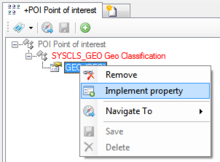
- Implement the GEO property on the specific object with Implement property from the context menu
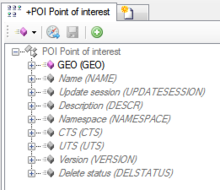
- Check if the GEO property was created correctly
- The object needs to be added to the list of infrastructure objects of the according Context, there are two different ways to achieve that:
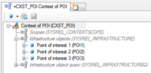
- Individual objects can be added directly to the Infrastructure relation in the ACM using the Relation Editor.
- Individual objects can be added directly to the Infrastructure relation in the ACM using the Relation Editor.
| Only the objects which are located directly undneath the Infrastructure relation will be part of the infrastructure. Their child objects will NOT be included (automatically). |
- To add multiple objects of the same type, a query has to be created and added to the Infrastructure query relation in the ACM.
- To add multiple objects of the same type, a query has to be created and added to the Infrastructure query relation in the ACM.
| Don't forget to fill out the Geo data (Latitude, Longitude, Altitude) of the object(s) you want to see using the Object Editor or Bulk Editor with reasonable values in context to your location! |


