Difference between revisions of "Location Manager"
(→Best Practices) |
|||
| (5 intermediate revisions by 3 users not shown) | |||
| Line 34: | Line 34: | ||
== Working Principle == | == Working Principle == | ||
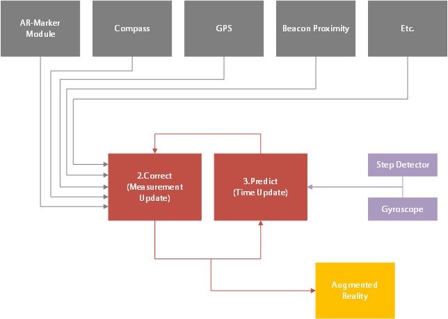
| − | Internally the Location Managers uses an Extended Kalman Filter to combine and filter pose estimation systems, based on their probabilistic error levels. Each Pose Estimation System is therefore associated with a variance level (squared standard deviation), describing the expected uncertainty. Precise systems, such as [[AR- | + | Internally the Location Managers uses an Extended Kalman Filter to combine and filter pose estimation systems, based on their probabilistic error levels. Each Pose Estimation System is therefore associated with a variance level (squared standard deviation), describing the expected uncertainty. Precise systems, such as [[AR-Marker]], are associated with a lower variance than inaccurate systems such as [[GPS]]. |
The Kalman Filter keeps track of the current device pose (= best estimate) and the associated uncerctainty. The operation is subdivided into two stages: Prediction and Correction. | The Kalman Filter keeps track of the current device pose (= best estimate) and the associated uncerctainty. The operation is subdivided into two stages: Prediction and Correction. | ||
| Line 43: | Line 43: | ||
[[File:EKF.png|700 px|center|thumb|alt=Extended Kalman Filter|Extended Kalman Filter]] | [[File:EKF.png|700 px|center|thumb|alt=Extended Kalman Filter|Extended Kalman Filter]] | ||
| − | + | ||
| − | + | ||
== Best Practices == | == Best Practices == | ||
| − | [[AR-Marker]] and [[Gyroscope]] are the most precise pose estimation systems. Thus it is adviced to activate them in any case. Especially in the proximity of POIs [[AR- | + | [[AR-Marker]] and [[Gyroscope]] are the most precise pose estimation systems. Thus it is adviced to activate them in any case. Especially in the proximity of POIs [[AR-Marker]] should be deployed, to provide a good AR-experience. Furthermore it is recommended to activate the [[Step Detector]] in scenarios, where the mobile device points into walking direction (i.e. the operator is not expected to walk sideward). |
| − | In indoor environments and environments with strong magnetic fields the [[Compass]] and [[GPS]] Pose Estimation Systems should be deactivated. [[Routing- | + | In indoor environments and environments with strong magnetic fields the [[Compass]] and [[GPS]] Pose Estimation Systems should be deactivated. [[Routing-Graph Snapping]] should only be activated and configured where the user is in the proximity of the graph (e.g. on corridors). |
| − | |||
| − | |||
| − | =WinX= | + | |
| − | The Location Manager | + | |
| + | =UWP/WinX/Xamarin= | ||
| + | The Location Manager controls the different positioning services that are available for mobile devices. | ||
| + | |||
| + | == PoseFusion == | ||
| + | There is a toggle for using the Posefusion functionality. | ||
== Possible Positioning Modes == | == Possible Positioning Modes == | ||
| − | There are three different modes available for the Location Manager. The names and defined behaviors are: | + | There are three different modes available for the Location Manager. The names and defined behaviors of the three modes are: |
{| class="wikitable sortable" | {| class="wikitable sortable" | ||
| Line 69: | Line 72: | ||
| BEACON_PROXIMITY_MODE || class="centeredCell" | {{bullet_empty}} || class="centeredCell" | {{bullet_full}} || class="centeredCell" | {{bullet_full}} | | BEACON_PROXIMITY_MODE || class="centeredCell" | {{bullet_empty}} || class="centeredCell" | {{bullet_full}} || class="centeredCell" | {{bullet_full}} | ||
|} | |} | ||
| + | |||
| + | |||
<headertabs/> | <headertabs/> | ||
| Line 75: | Line 80: | ||
[[Category:Android|Location Manager]] | [[Category:Android|Location Manager]] | ||
[[Category:WinX|Location Manager]] | [[Category:WinX|Location Manager]] | ||
| + | [[Category:Xamarin|Location Manager]] | ||
| + | [[Category:Client|Location Manager]] | ||

